Routing with pgRouting: Catchment Area Calculation
For a long time I’ve wanted to play with pgRouting and that time has finally come. Among many other routing functions there is one that caught my eye, called pgr_drivingdistance. As the documentation says, it returns the driving distance from a start node using Dijkstra algorithm. The aforementioned distance doesn’t need to be defined in Euclidean space (the real distance between two points), it might be calculated in units of time, slopeness etc. How to get it going?
Data
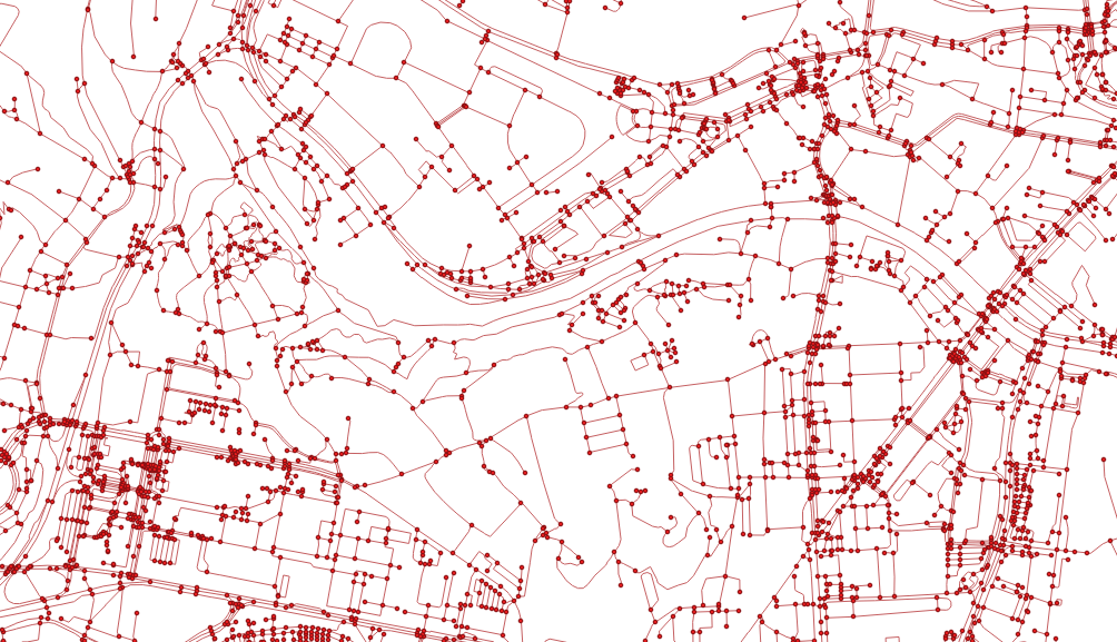
OSM will do as it always does. There is a tool called osm2pgrouting to help you load the data, the pure GDAL seems to be a better way to me though. Importing the downloaded data is trivial.
ogr2ogr -f "PostgreSQL" PG:"dbname=pgrouting active_schema=cze" \
    -s_srs EPSG:4326 \
    -t_srs EPSG:5514 \
    roads.shp \
    -nln roads \
    -lco GEOMETRY_NAME=the_geom \
    -lco FID=id \
    -gt 65000 \
    -nlt PROMOTE_TO_MULTI \
    -clipsrc 16.538 49.147 16.699 49.240
To route the network, it has to be properly noded. Although pgRouting comes with built-in pgr_nodenetwork, it didn’t seem to work very well. To node the network, use PostGIS ST_Node. Note this doesn’t consider bridges and tunnels.
CREATE TABLE cze.roads_noded AS
SELECT
    (ST_Dump(geom)).geom the_geom
FROM (
    SELECT
        ST_Node(geom) geom
    FROM (
        SELECT ST_Union(the_geom) geom
        FROM cze.roads
    ) a
) b;
After noding the network, all the information about speed limits and oneways is lost. If needed, it can be brought back with following:
CREATE INDEX ON cze.roads_noded USING gist(the_geom);
ALTER TABLE cze.roads_noded ADD COLUMN id SERIAL PRIMARY KEY;
ALTER TABLE cze.roads_noded ADD COLUMN maxspeed integer;

UPDATE cze.roads_noded
SET maxspeed = a.maxspeed
FROM (
    SELECT DISTINCT ON (rn.id)
        rn.id,
        r.maxspeed
    FROM cze.roads_noded rn
    JOIN cze.roads r ON (ST_Intersects(rn.the_geom, r.the_geom))
    ORDER BY rn.id, ST_Length(ST_Intersection(rn.the_geom, r.the_geom)) DESC
) a
WHERE cze.roads_noded.id = a.id;
With everything set, the topology can be built.
ALTER TABLE cze.roads_noded ADD COLUMN source integer;
ALTER TABLE cze.roads_noded ADD COLUMN target integer;
SELECT pgr_createTopology('cze.roads_noded', 1);
This function creates the cze.roads_noded_vertices_pgr that contains all the extracted nodes from the network.
As already mentioned, measures other than length can be used as a distance, I chose the time to get to a given node on foot.
ALTER TABLE cze.roads_noded ADD COLUMN cost_minutes integer;
UPDATE cze.roads_noded
SET cost_minutes = (ST_Length(the_geom) / 83.0)::integer; -- it takes average person one minute to walk 83 meters

UPDATE cze.roads_noded
SET cost_minutes = 1
WHERE cost_minutes = 0;
Routing
Now the interesting part. All the routing functions are built on what’s called inner queries that are expected to return a certain data structure with no geometry included. As I want to see the results in QGIS immediately, I had to use a simple anonymous PL/pgSQL block that writes polygonal catchment areas to a table (consider it a proof of concept, not the final solution).
DROP TABLE IF EXISTS cze.temp;
CREATE TABLE cze.temp AS
SELECT *
FROM cze.roads_noded_vertices_pgr ver
JOIN (
    SELECT *
    FROM pgr_drivingDistance(
        'SELECT id, source, target, cost_minutes as cost, cost_minutes as reverse_cost FROM cze.roads_noded',
        6686,
        10,
        true
    )
)dist ON ver.id = dist.node;

DO $$
DECLARE
    c integer;
BEGIN
    DROP TABLE IF EXISTS tmp;
    CREATE TABLE tmp (
        agg_cost integer,
        geom geometry(MULTIPOLYGON, 5514)
    );

    -- order by the biggest area so the polygons are not hidden beneath the bigger ones
    FOR c IN SELECT agg_cost FROM cze.temp GROUP BY agg_cost HAVING COUNT(1) > 3 ORDER BY 1 DESC LOOP
        RAISE INFO '%', c;
        INSERT INTO tmp (agg_cost, geom)
        SELECT
            c,
            ST_Multi(ST_SetSRID(pgr_pointsAsPolygon(
                'SELECT
                        temp.id::integer,
                        ST_X(temp.the_geom)::float AS x,
                        ST_Y(temp.the_geom)::float AS y
                FROM cze.temp
                WHERE agg_cost = ' || c
            ), 5514));
    END LOOP;
END$$;
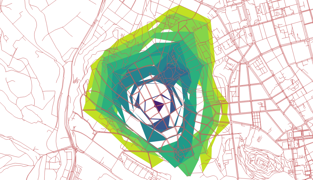
Using pgr_pointsAsPolygon renders resulting nodes accessible in 10-minute walk in polygons, but weird looking ones. Not bad, could be better though.
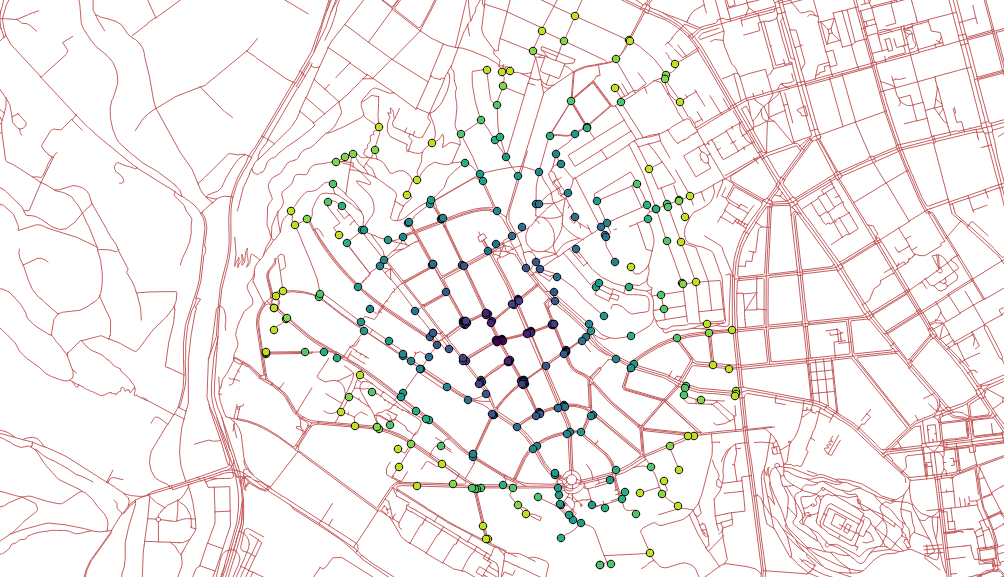
How about seeing only nodes instead of polygons?
SELECT
    agg_cost,
    ST_PointN(geom, i)
FROM (
    SELECT
        agg_cost,
        ST_ExteriorRing((ST_Dump(geom)).geom) geom,
        generate_series(0,ST_NumPoints(ST_ExteriorRing((ST_Dump(geom)).geom))) i
    FROM tmp
) a;
Looks good, could be better though.
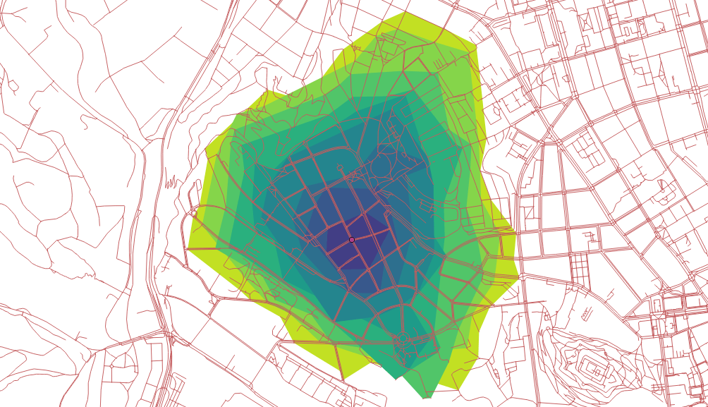
How about creating concave hulls from the extracted nodes?
SELECT
    agg_cost,
    ST_ConcaveHull(ST_Union(geom)) geom
FROM (
    SELECT
        agg_cost,
        ST_PointN(geom, i) geom
    FROM (
        SELECT
            agg_cost,
            ST_ExteriorRing((ST_Dump(geom)).geom) geom,
            generate_series(0,ST_NumPoints(ST_ExteriorRing((ST_Dump(geom)).geom))) i
        FROM tmp
    ) a
) b
GROUP BY agg_cost
ORDER BY agg_cost DESC;
This one looks the best I guess.
Remarks
- The documentation doesn’t help much.
- I’d expect existing functions to return different data structures to be easy-to-use, actually.
LATERALmight be really handy with those inner queries, have to give it a shot in the future.- Pedestrians usually don’t follow the road network.
- Bridges and tunnels might be an issue.